KARACS, FERENC: MAP OF CROATIA, SLAVONIA, DALMATIA AND BOSNIA
Inventory number 190
Author: KARACS, FERENC
Original title: KARTA HRVATSKE, SLAVONIJE, DALMACIJE I BOSNE
Publishing year: 1830
Place of publishing and publisher: Budapest
Format: 16,8 x 19 cm
Technique: Partially coloured lithograph
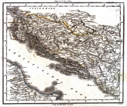
This map of Croatia, Slavonia, Dalmatia and Bosina, was made by Ferenc Karacs, (17771-1838), Hungarian cartographer and engraver active in Budapest during the first half of the 19th century. The map shows state borders and the network of roads and settlements. It was produced, in all probability, to be included in some of the school atlases of the time. Along the upper and bottom margins of the map geographical coordinates based on a prime meridian through Ferro, i.e. Paris are indicated.
KARACS, FERENC
KARACS, FERENC (FRANJO KARAČ) (1771-1838), a Hungarian cartographer and copper-plate engraver (Püspökladany). His most famous work is Karten, published between 1793 and 1806. He made a map of Hungary and the surrounding coutries, and in 1822, by the order of Bishop Maksimilijan Vrhovac and in collaboration with Josip Szeman, he made a large copper-plate map of the Zagreb Archdiocese (Mappa Diocesis Zagrabiensis). Karacs’s task was to engrave the content and the graphic equipment. On the third sheet there was a large veduta of Zagreb. In the early 19th century he worked on the map of the Bosnian or Đakovo-Srijem Archdiocese, with their respective parishes, which he completed in 1826.
