LUČIĆ, IVAN (IOANNES LUCIO): MAP OF ILLYRICUM
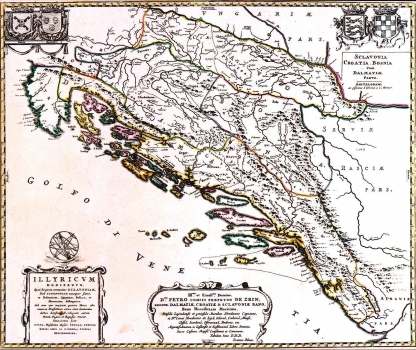
The author of this map is the Croatian historian, Ivan Lučić, founder of the Croatian historiography. For his most known work “O kraljevstvu Dalmacije i Hrvatske” (De Regno Dalmatiae et Croatiae libri sex)” published in 1668 in Amsterdam by the Dutch cartographer and publisher Johannesa Bleaua, Lučić made six historical maps of the Croatian lands. It is true, Lučić's had not drawn his maps himself, but he is the author of their content. In fact, Bleau drew the map after the formation supplied by Lučić. The last and the most important was exactly the map "Illyricum hodiernum" showing Illyricum within the borders as established by the ecclesiastical court in Rome, in 1653, when a decision was made that the notion Illyric would include Dalmatia, Croatia, Slavonia and Bosnia and exclude Carinthia, Carniola and Styria. An unchanged issue of this map was later published in Bleau's atlas "Atlas Maior sive Geographia Blaeuviana". This copy of the map was published in the atlas of Jean Covens and Cornelis Mortier, most probably in the edition of their "Nieuwe Atlas" published in 1730. This map is known for the most part because it was dedicated to the viceroy (ban) Petar Zrinski. Along the upper margin edge the coats of arms of Bosnia, Dalmatia and Croatia are drawn. The title of the map is in its lower left corner, while the text of dedication to Zrinski, signed by Bleau, is across the central part of the lower margin edge.
LUČIĆ, IVAN
