LOTTER, TOBIAS CONRAD: CROATIA, BOSNIA, SERBIA
Inventory number 401
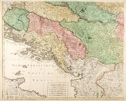
Original title: Carte Geographique du Theatre de la Guerre en General representant le Royaume de Hongrie, la Principalite de Transylvanie, et les Royaumes de Crocie, de Dalmacie, de Esclavonie, de Bosnie, de Servie...
Publishing year: 1771
Place of publishing and publisher: Augsburg
Format: 47 x 58 cm
Technique: Coloured copper engraving
The map is the left lower sheet of a large (94x118 cm) map created on four sheets, showing the area of war against the Ottoman Empire from Lika to the Black Sea and the Danube River from Vienna to the Black Sea. Since it is only slightly different from the map Theatre de la Guerre by Pierre Mortier from 1710, it is no surprise that Lotter repeated similar errors, which can be seen on the Ottens brothers' map. Namely, Dalmatia and Herzegovina in the north almost reach Sarajevo, which is moved to the north almost to Tuzla. In the east, Bosnia is deeply within Serbia and occupies Kosovo and Macedonia, almost to Skopje and Vardar River. The fact that maps did not change over 70 years, regardless of Srijemski Karlovci Peace in 1699 and Požarevac Peace in 1718, is evidence of a certain stagnation in French and Dutch cartography in the 18th century and that these were soon represented much more reliably by Austrian cartographers.
LOTTER, TOBIAS CONRAD
LOTTER, TOBIAS CONRAD (1717-1777), an engraver, cartographer and publisher from Augsburg. He married a daughter of M. Seutter and succeeded him in 1757. His most known works are Terra Sancta from 1759, Sardinia/Corsica from 1764, Die Welt from 1775, and reissues from 1778 and 1782, Atlas Minor, which was published from 1740 to 1744 with the help of Seutter and the Atlas Geogr. Portatilis. He published the maps together with Tobias Lobeck, an engraver and publisher in the Atlas Geographicus in 1762. As early as 1770, his work Carte Geographique representant la Mer Mediterranée ou la seconde Partie Du Théatre De La Guerre Entre Les Russes Et Les Turcs : C'est à dire Les Roiaumes, Les Etâts, Les Provinces Et Les Diverses Isles Situées Dans La Dite Mer, avec La Mer Noire ou Pont Euxine et une Partie de la Province Georgie en Asia was published in Augsburg.