LICHTENSTERN, JOSEPH MARX VON: ISTRIA AND DALMATIA
Inventory number 414
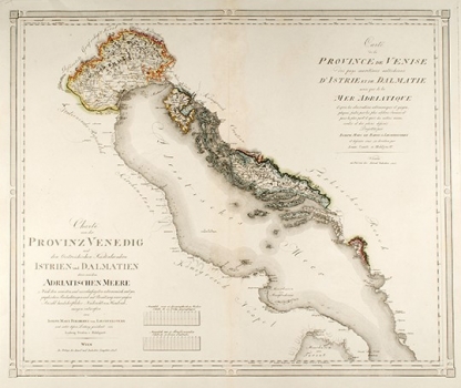
Original title: Charte von der Provinz Venedig und den Oesterreichischen Kustenlandern Istrien und Dalmatien dann von Adriatischen Meere / Carte de la Province de Venise da pays maritimes autrichiens d'Istrie et de la Dalmatie ainsi que da la Mer Adriatique
Publishing year: 1805
Place of publishing and publisher: Verlag Kunst und Industrie Comptoirs, Wien
Format: 52 x 62,5 cm
Technique: Partially coloured lithograph
The large format map was conceived by the Austrian historian, geographer and cartographer J. M. Freiherr von Liechtenstern (1765-1828) and drafted by Count Ludwig von Hohlgartt. The map depicts the Venetian Republic and its possessions in Istria and Austrian possessions in Dalmatia at the time of the Peace of Bratislava in 1805. The Venetian Republic is in the possession of the French and its holdings are not yet part of the Illyrian Provinces, which were founded in 1809. According to the text in the cartouche, the map was "made according to the most recent observations of the most famous scientists", and although it is very detailed, it is not particularly legible. However, the Austrian property in Istria and the special status of the Republic of Dubrovnik are illustrated well. This map was printed by a very influential and active publisher, Kunst und Industrie Comptoirs in Vienna, which operated from 1801 to 1833 and published many maps, scientific papers, as well as Ludwig van Beethoven’s music.
LICHTENSTERN, JOSEPH MARX VON
LICHTENSTERN, JOSEPH MARX VON (1765 - 1828), a Viennese naturalist, geographer and cartographer. In the late 1780s he managed the estates owned by Count Batthyany in Lower Austria, Styria and Carniola, and in Hungary and Croatia. He founded the Cosmographic Society in Vienna in 1790, introduced statistics into the study of geography and upgraded cartography with topographical data. His most famous works are Istrien from 1801, Charten von der Provinz Venedig und den österreichischen Küsteslaendern Istrien und Dalmatien from 1805, Karte von Königreiche Ungarn mit Einschluss der Königreiche Kroazien und Slovenien, dann von dem Grossfürthentume Siebenbürgen in 6 sheets from 1809 and Handbuch der neusten Geographie des österreichischen Kaiserstaats, which he published between the late 1817 and early 1818. His son, MAXIMILLIAN JOSEPH VON LICHTENSTERN (1792-1850) from Vienna was a military cartographer.