Hrvatski Deutsch English
Home Maps Authors k-o LODOLI Pianta o sia Dissegno delle pertinenze di Vrana
LODOLI, GIOVANNI BATTISTA: LAKE VRANSKO

LODOLI, GIOVANNI BATTISTA: LAKE VRANSKO

Inventory number 410
Original title: Pianta o sia Dissegno delle pertinenze di Vrana...
Publishing year: 1755
Place of publishing and publisher:
Format: 45 x 72 cm
Technique: Copper engraving

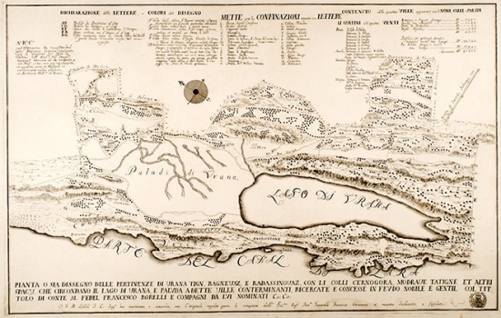
The map details the Vrana Lake and its surroundings, i.e. the property of Francesco Borelli, who, by investiture in 1752, acquired the title 'Prince of Vrana' and added Vranski to his surname. In the period from 1754 to 1759, the Venetian General Provveditore Francesco Grimani ruled Dalmatia. He wanted to regulate ownership and property relations in Zadar and its surroundings, and he did so in 1756 with the so-called Grimani's law. It is assumed that the map was designed for proving the ownership of the Borelli family and that it represents an updated copy of the cadastral plan kept in the Zadar archive. The map therefore contains many of the features of the plan, as well as detailed legends of the property, village and hamlet details and sales information. The original cadastral plan seems to have been coloured, because a part of the legend by the top edge of the map describes in detail the colours used to mark individual boundaries of the property. The map’s technical execution is very clever, the impression is excellent and even, the format plate is unusual but with adequate content and the paper is of a high quality, so it is a great shame that authors or publishers aren’t signed somewhere on the map. It is only clear that a certain engineer, J. C. Lodoli, compared that design with the original, but it is unknown if he participated in map making.

LODOLI, GIOVANNI BATTISTA
LODOLI, GIOVANNI BATTISTA (JOHN THE BAPTIST) a Venetian military engineer who in the second half of the 18th century produced sketches and maps of Vransko estate for Count Francesco Borelli, who was originally from Bologna. After being hired by the owner of the Vransko estate in about 1755, he produced a map of Podgorje and a part of the Velebit Canal from Lukovo on the west to Knin on the east, including the entire Ravni kotari and the Lake Vrana. The name of the map is Pianta o sia Dissegno delle pertinenze di Vrana… The map confirms the ownership of the Borelli family over the estate, which they had received as an investiture in 1752. The map most probably represents an adaptation of an older map created in the late 17th century. Lodoli created maps and compared them to the original cadastral plan, though it is not entirely certain that he personally was the creator of the original. Still, primarily due to his work as a military engineer and land surveyor in Dalmatia, it is more likely that the map was created by Lodoli, and not the nobleman Borelli. Namely, in addition to the maps and sketches of military buildings, Lodoli also worked as a military engineer on the Skradin Cathedral.
Print Friendly and PDF
Top