KIPFERLING, JOSEPH KARL: SLAVONIA
Inventory number 371
Author: KIPFERLING, JOSEPH KARL
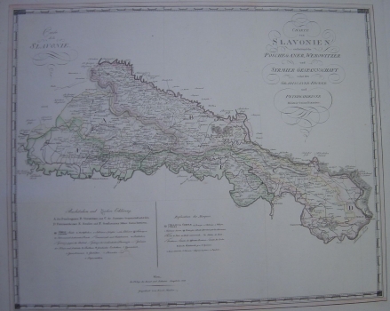
Original title: Charte von Slavonien enhaltend die Poscheganer, Werowitzer und Syrmier Gespannschaft nebst den Gradiscaner Broder und Peterwardeiner Militair Granz Districten / Carte de la Slavonie
Publishing year: 1805
Place of publishing and publisher: Wien, Verlag Kunst und Industrie Comptoirs
Format: 47 x 58,5 cm
Technique: Coloured copper engraving
The map originates from the atlas "Atlas des Oesterreichischen Kaiserthums", published in Vienna in 1805. It depicts Slavonia as an area between Sava, Drava and Danube, from Kutina in the West to Belgrade in the east. Much of the area, especially along the Sava River, represents the Military Border and is divided into corresponding districts. Relief, shown by shading, is relatively faintly visible, unlike wetlands. Most attention is devoted to traffic communication, which includes postal routes and stations. The name Karl Müller of the copper engraver is mentioned at the bottom of the map.
KIPFERLING, JOSEPH KARL
KIPFERLING, JOSEPH KARL - an Austrian cartographer from the first half of the 19th century. He worked in Vienna, with Kindermann, Walch and Müller. His most notable works are Oest. Monarchie from 1803, Empire Autriche from 1805, Reise Atlas, published in Vienna in 1804, the book Nieder-Ungern : II. Blatt enthaltend die Pressburger, Neitraer, Trentschiner, Thurozer, Arver, Liptauer, Sohler, Neograder, Honter Und Barscher Gespannschaft = II. Partie De La Basse Hongrie from 1803 and Atlas des Ö̈sterreichischen Kaiserthums from 1804.
