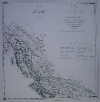
KIPFERLING, JOSEPH KARL: CROATIAN COAST FROM EASTERN ISTRIA TO ŠIBENIK
Inventory number 370
Author: KIPFERLING, JOSEPH KARL
Original title: Charte des Nordwestlichen Theiles von Dalmatien/ Partie da la Dalmatie du Nord Ouest
Publishing year: 1805
Place of publishing and publisher: Verlag Kunst und Industrie Comptoirs, Wien
Format: 47 x 45 cm
Technique: Partially coloured copper engraving
The map is a part of a series showing sections of Croatia that became parts of the Austrian Empire as a result of the fall of the Venetian Republic. As such, this series was published in the atlas called "Atlas des Oesterreichischen Kaiserthums", which displays the Croatian coast from Eastern Istria to Šibenik. The green border shows the line of delimitation between the Austrian and Ottoman empires in the hinterland. Relief is depicted by shading and Velebit is particularly emphasized. The map also contains postal stations and routes. When the French Illyrian Provinces were founded four years later, in 1809, the political-administrative content of the map no longer corresponded to reality.
KIPFERLING, JOSEPH KARL
KIPFERLING, JOSEPH KARL - an Austrian cartographer from the first half of the 19th century. He worked in Vienna, with Kindermann, Walch and Müller. His most notable works are Oest. Monarchie from 1803, Empire Autriche from 1805, Reise Atlas, published in Vienna in 1804, the book Nieder-Ungern : II. Blatt enthaltend die Pressburger, Neitraer, Trentschiner, Thurozer, Arver, Liptauer, Sohler, Neograder, Honter Und Barscher Gespannschaft = II. Partie De La Basse Hongrie from 1803 and Atlas des Ö̈sterreichischen Kaiserthums from 1804.
