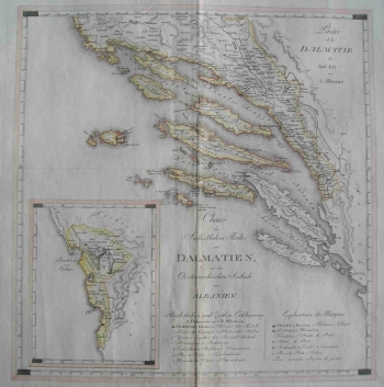
KIPFERLING, JOSEPH KARL: MAP OF THE SOUTHEASTERN PART OF DALMATIA
This Kipferling’s map was published in his atlas titled «Atlas des Österreichischen Kaiserthums» in the 1805 edition published by «Kunst und Industrie Comptoirs». It shows the then southern part of Dalmatia with a part of Albania (the Gulf of Kotor, Bocca di Cattaro) shown in an inset map placed in the lower left corner of the map. The map features the above regions after the fall of the Venetian Republic during the so-called period of the first Austrian administration (1797-1805), before the French stormed the region in 1808 and ended the independence of a centuries-old Republic of Dubrovnik which can be seen on this map as it was during its last days. The signature of the engraver Franz Thade Müller is placed in the lower left corner of the map.
KIPFERLING, JOSEPH KARL
