KIPFERLING, JOSEPH KARL: MAP OF CROATIA
Inventory number 347
Author: KIPFERLING, JOSEPH KARL
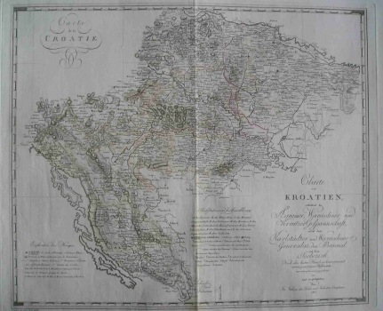
Original title: Charte von Kroatien, enthaltend dei Agramer, Varasdiner und Kreutzer Gespannschaft, nebst dem Karlstädter und Warasdiner Generalat, dem Bannal und dem Seebezirk. Nach dem besten Handzeichungen und anderen zuverlässingen Hülfsmitteln neu entvorfen und gezeichnet von Karl Joseph Kipferling. Wien im Verlage des Kunst und Industrie Comptoirs 1803.
Publishing year: 1803
Place of publishing and publisher: Wien, Verlag des Kunst und Industrie Comptoirs
Format: 48,5 x 59 cm
Technique: Partially coloured copper engraving
This Kipferling’s map is from the 1805 edition of the atlas «Atlas des Österreichischen Kaiserthums» published in «Kunst und Industrie Comptoirs». It shows the then Croatia with the Military Frontier. The borderlines between Zagreb, Varaždin and Križevci counties are shown, as well as the Littoral zone and Varaždin and Karlovac general commands and Banatian Frontier with their regiments that constituted the Croatian Military Frontier. In the lower left corner the map has the signature of the engraver Franz Thade Müller.
KIPFERLING, JOSEPH KARL
KIPFERLING, JOSEPH KARL - an Austrian cartographer from the first half of the 19th century. He worked in Vienna, with Kindermann, Walch and Müller. His most notable works are Oest. Monarchie from 1803, Empire Autriche from 1805, Reise Atlas, published in Vienna in 1804, the book Nieder-Ungern : II. Blatt enthaltend die Pressburger, Neitraer, Trentschiner, Thurozer, Arver, Liptauer, Sohler, Neograder, Honter Und Barscher Gespannschaft = II. Partie De La Basse Hongrie from 1803 and Atlas des Ö̈sterreichischen Kaiserthums from 1804.
