MERIAN, MATTHÄUS: KLIS AND SPLIT AND THE SURROUNDING COUNTRYSIDE
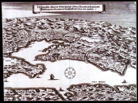
This map featuring the surrounding area of Split and Klis was published in Merian’s work “Theatri Europei Oder Historische Beschreibung aller Vornemdsten und denckwürdigsten Geschichten, so sich hin weider in Europa sonderlich im Reich Teucher Nation von Anno 1642 bis Anno 1647. “. The map was inspired by the battle for the liberation of Klis (1648) led by Leonardo Foscolo. Based on the information brought back, one map was compiled, in 1648, by a Venetian cartographer showing the positions of troops in the Split and Klis area. Although, Merian omitted the representation of military operations, the influence of the above mentioned source on his map is obvious. We see the town of Split comprised within the Palace of Diocletian. All of the main buildings such as fortress, quarantine houses, towers and the cathedral can be recognized within the space enclosed by the Palace. The Mount Marijan is drawn with many inaccuracies. Small votive churches are shown on the mount Marjan, specifically the church of St. Nicholas, St. Stephen, St. Francis, St. George and St. Jerome. In the area of Poljud the Franciscan church with the monastery can be seen. Solin is shown approximately only as ruins of the antique Salona. Klis and Split are nicely detailed. The fortress and the suburb are clearly seen. The map area reaches eastwards from the west half of Omiš to the east half of Trogir on the West. In the waterfront parts of islands of Čiovo (Bua), Šolta (Solta) and Brač (Brazza) can be seen. The title of the map is placed below its top margin.
MERIAN, MATTHÄUS
