MERIAN, MATTHÄUS: DUBROVNIK'S HINTERLAND
Inventory number 68
Author: MERIAN, MATTHÄUS
Original title: Erschöcklicher Untergang und Verbrenung der Statt Ragusa
Publishing year: 1680
Place of publishing and publisher: Frankfurt
Format: 22 x 32,5 cm
Technique: Copper engraving
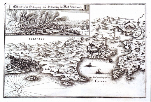
This Merian's map image was first published in 1690 in the work of L. Gottfridt "Archonotologia Cosmica". The same as the map representing the hinterland of Šibenik, the map of Dubrovnik's hinterland is drawn from a semi perspective view. The town of Dubrovnik is featured very precisely with its fortresses and the cathedral that can be easily recognized. To the east of Dubrovnik are shown Cavtat place and the entire Gulf of Bocche di Cattaro with places Novi and Kotor. In the upper left corner is a separate box with a view of Dubrovnik. It represents Dubrovnik during the earthquake of 1667 that was very destructive. The picture of the town in flames isn't however quite realistic.
MERIAN, MATTHÄUS
MATTHÄUS MERIAN (1593-1650) a German topographer, graphic artist, and editor. He studied in Zürich, and worked in Frankfurt. His most famous work, "Theatrum Europeam" went through many editions between 1629 and 1718, and "Archeologica Cosmica" reissued as well several times during the period from 1638 to 1649.
