MERIAN, MATTHÄUS: ZADAR AND ŠIBENIK HINTERLAND
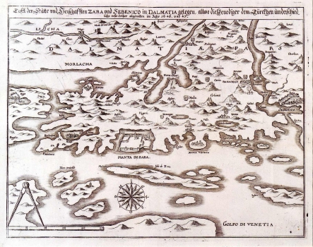
This Merian's map image of Senj was published in one of his "Theatrum Europaeum" editions. The hinterland of Zadar and Šibenik is the area of focus on this map. It was based on Martin Rota Kolunić's 1570 map, although if we consider its content, compared to the model this map is considerably simplified. The flows of Lika, Zrmanja and Krka rivers are particularly accentuated. The topography is shown in a quite inaccurate way with arbitrarily located shaded elevations. The representation of the mountain range of Velebit is completely omitted. The area at the foot of the mountain range is marked as Morlacha. The towns of Nin, Zadar, Biograd, Šibenik and Skradin are shown in simplified view images. Among the places located inland only those having a fortress are denoted. The island of Ugljan (Isola di Zara) is to be seen in the foreground, and to the west from it there are the islands of Molat (Zapuntelo), Sestrunj and Zverinac. The fortresses owned by the Venetians are denoted by a symbol of lion. The title is above the upper margin edge.
MERIAN, MATTHÄUS
