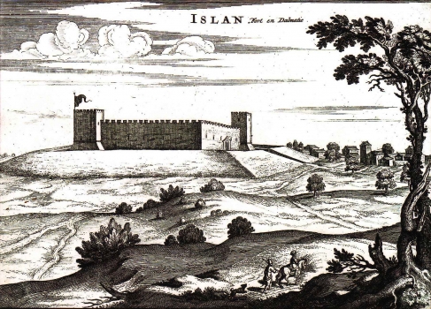
MORTIER, PIERRE: VIEW OF THE TOWN OF ISLAM
This view of Nadin by Mortier is an unchanged issue of the map first published in the Coronell's atlas "Isoalrio dell Atlante Veneto". It was published in Mortier's atlas on page 197. The view shows Islam, which is today a small settlement in the hinterland of Zadar, while held occupied by the Turks, between 1538 and 1684. Islam was Turkish border stronghold until the beginning of the Cyprus War of 1570. On this map the town is shown as it was during the Turkish rule. In 1684, after the expulsion of the Turks, Islam became again one of the Venetian strongholds. The map shows the fortified town of Islam as a quadrangular fortress provided with two four-sided bastions in a slanting position. The village of Islam is shown at the foot of the fortress. The author adorned the view with a drawing of two Turkish solders walking along the access road.
MORTIER, PIERRE
