JANSSONIUS, JAN: MAP OF PANNONIA AND ILLYRICUM
Inventory number 69
Author: JANSSONIUS, JAN
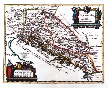
Original title: Veteris Pannonia Utriusque Nec non Illyrici Desscriptio Geographica / Jan (Johann) Janssonius
Publishing year: 1700
Place of publishing and publisher: Amsterdam
Format: 38,5 x 47,5 cm
Technique: Partially coloured copper engraving
This historical map of the antique Pannonia and Illyricum by its content is identical to the map by Abraham Ortelius entitled "Pannonia et Illyrici veteris tabula" of 1595 (ref. catalogue No. 42). Different are only its decorative elements. The title of the map is shown in the upper right corner in a Renaissance cartouche. The cartouche placed in the lower left corner of the map contains the names of ethnic groups that inhabited the area. This cartouche is decorated with doge`s figure and a lion, symbols of the Republic of Venice.
JANSSONIUS, JAN
After Henricus Hondius death, the work was continued by JAN (JOHANN) JANSSONIUS (1588-1664), a Dutch cartographer and publisher who edited as well new editions of the Atlas Mercator-Hondius. In 1633, he became related to Henric Hondius by marriage. As Hondius possessed Mercator's engraving plates, they collaborated on new editions of the Mercator's atlas. In 1633 they published the second edition of the Atlaa Mercator-Hondius. The most important work of Jan Janssonius is the atlas "Theathre du Monde" published in 1639 in three volumes. Due to the fact that it was regularly revised and expanded its 1662 version comprised as much as 11 volumes. In 1694 Peter Schenk (approx. 1645-1715) bought Janssonius's engraving plates.
