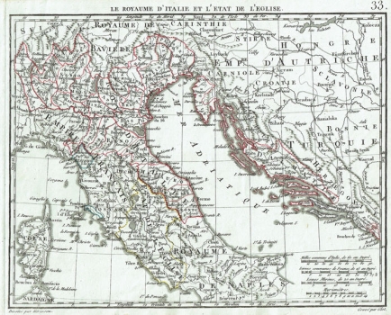
THE KINGDOM OF ITALY AND THE PAPAL STATES
This is a rare map of Northern Italy and the Papal States published in Paris by a geographical engineer and cartographer Eustache Herisson in the work Atlas Portatif, contenant la Geographie Universelle Ancienne et Moderne in 1809. The author is signed below the bottom edge of the map. The geographical content was engraved into the copper plate by C.B. Glot, which is also noted below the bottom edge. Above the top edge is the number 33 marking the page. The bottom corner contains four graphical scales measured in different units. Among the Croatian countries, Istria, Croatia, Dalmatia and Slavonia are clearly separated, while the information on the territory holder (Turquie) extends across Herzegovina and Bosnia. In Istria, there is a visible division between the Venetian and Austrian possessions, while the border with the Ottomans is marked on the Una and Sava Rivers.
HERISSON, EUSTACHE
