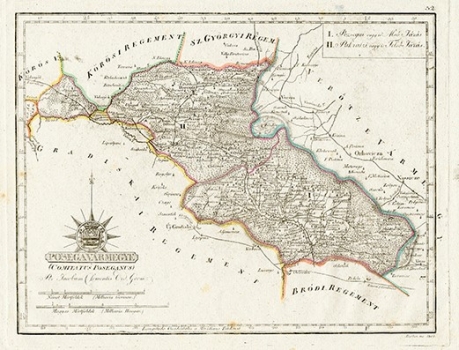
GOERÖG (GORÖG), DEMETER: THE DISTRICT OF POŽEGA
Inventory number 486
Author: GOERÖG (GORÖG), DEMETER
Original title: Posegavarmegye (Comitatus Poseganus)
Publishing year: 1802 - 1811
Place of publishing and publisher: Wien
Format: 21,7 x 28,2 cm
Technique: Lithograph, partialy coloured boundary lines
The Požega County map is divided into two districts: Požega and Pakrac. Since the whole area is forested, the map is difficult to read. It shows a part of Slavonia, which was surrounded by regiments of the Military Frontier. Daruvar, Pakrac, Požega and Pleternica can be discerned among larger settlements. Relief is almost invisible, so Psunj can not be seen at all.
GOERÖG (GORÖG), DEMETER
GOERÖG (GORÖG), DEMETER (1760-1833), a cartographer and manufacturer of globuses from Budapest. In 1789, with the financial support of Duke Miklos Eszterhazy, he opened his cartographic publishing house. His most famous work is Magyar Atlas, published in 1802 and again in 1841.
