GOERÖG (GORÖG), DEMETER: THE DISTRICT OF KRIŽEVCI
Inventory number 485
Author: GOERÖG (GORÖG), DEMETER
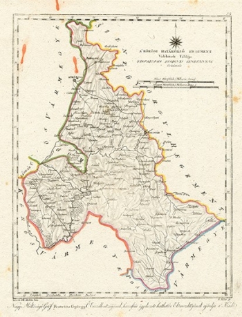
Original title: A Korosi Hatarorzo Regement
Publishing year: 1802 - 1811
Place of publishing and publisher: Wien
Format: 29 x 22,5 cm
Technique: Lithograph, partialy coloured boundary lines
The map shows the area bounded to the east and south by the Križevac County, and to the west by the Đurđevac Regiment. The town of Križevci, after which the Regiment was named, is outside the Regiment area, but Bjelovar is within its borders. Čazma and Ivanić Grad are larger settlements. Rivers are relatively well-presented, with only Čazma and Velika being named. The map is dedicated to Count Đuro Feštetić.
GOERÖG (GORÖG), DEMETER
GOERÖG (GORÖG), DEMETER (1760-1833), a cartographer and manufacturer of globuses from Budapest. In 1789, with the financial support of Duke Miklos Eszterhazy, he opened his cartographic publishing house. His most famous work is Magyar Atlas, published in 1802 and again in 1841.
