GOERÖG (GORÖG), DEMETER: THE DISTRICT OF DURDEVAC
Inventory number 483
Author: GOERÖG (GORÖG), DEMETER
Original title: A szent Gyorgyi Hataarorzo Regement
Publishing year: 1802 - 1811
Place of publishing and publisher: Wien
Format: 29 x 22,5 cm
Technique: Lithograph, partialy coloured boundary lines
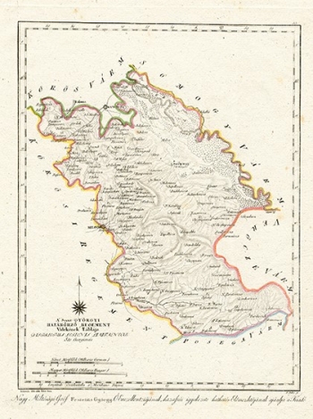
The map shows the part of the Military Frontier bounded to the east by the Križevci Regiment, in the west by the Drava River and the Virovitica County, and in the south by Požega County. It is a rural and afforested area, with no large places and with a poorly developed road network. Although it is named after Đurđevac, it is obvious that the area is gravitating towards Bjelovar, on the border with the Križevci Regiment. The map is dedicated to Count Đuro Feštetić, a descendant of a wealthy landowner's Hungarian family of Croatian origin whose property stretched from Balaton to Slavonia.
GOERÖG (GORÖG), DEMETER
GOERÖG (GORÖG), DEMETER (1760-1833), a cartographer and manufacturer of globuses from Budapest. In 1789, with the financial support of Duke Miklos Eszterhazy, he opened his cartographic publishing house. His most famous work is Magyar Atlas, published in 1802 and again in 1841.
