GOERÖG (GORÖG), DEMETER: THE DISTRICT OF KRIŽEVCI
Inventory number 471
Author: GOERÖG (GORÖG), DEMETER
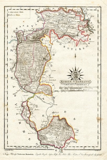
Original title: Koros Varmegye (Comitatus Crisiensis)
Publishing year: 1802 - 1811
Place of publishing and publisher: Wien
Format: 22,5 x 33 cm.
Technique: Lithograph, partialy coloured boundary lines
The shape of the map is very irregular. In the east it borders with the Military Frontier, i.e. the Križevci Regiment, which was still administratively under military rule. In the west it borders with Zagreb County and Varaždin County, and in the south with Požega County. Larger settlements are Ludbreg, Koprivnica, Kašina and Križevci. The road network is represented very well, and the relief is shown by hatching. The areas covered by the forest are also represented. It is interesting that the map is dedicated to the Zagreb bishop Maksimilijan Vrhovac, who, among other things, is responsible for the construction of Maksimir Park.
GOERÖG (GORÖG), DEMETER
GOERÖG (GORÖG), DEMETER (1760-1833), a cartographer and manufacturer of globuses from Budapest. In 1789, with the financial support of Duke Miklos Eszterhazy, he opened his cartographic publishing house. His most famous work is Magyar Atlas, published in 1802 and again in 1841.
