GOERÖG (GORÖG), DEMETER: DISTRIKT OF VARAŽDIN
Inventory number 432
Author: GOERÖG (GORÖG), DEMETER
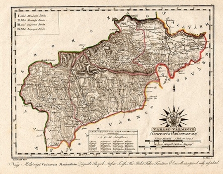
Original title: Varad Varmegye (Comitatus Varasdiensis)
Publishing year: 1802 - 1811
Place of publishing and publisher: Wien
Format: 29 x 36,4 cm
Technique: Partially coloured lithograph
The map shows the Varaždin County, which is situated between the Drava River, Sutla and Krapina, and covers the area we call Zagorje, including cities such as Krapina and Zagreb. The city of Varaždin looks more urban than the fortification that represents Zagreb on Görög's map of the Zagreb County. The map also features relief, as well as a detailed road network.
GOERÖG (GORÖG), DEMETER
GOERÖG (GORÖG), DEMETER (1760-1833), a cartographer and manufacturer of globuses from Budapest. In 1789, with the financial support of Duke Miklos Eszterhazy, he opened his cartographic publishing house. His most famous work is Magyar Atlas, published in 1802 and again in 1841.
