FLEMMING, CARL: MAP OF CROATIA, BOSNIA, SERBIA AND MONTENEGRO
Inventory number 380
Author: FLEMMING, CARL
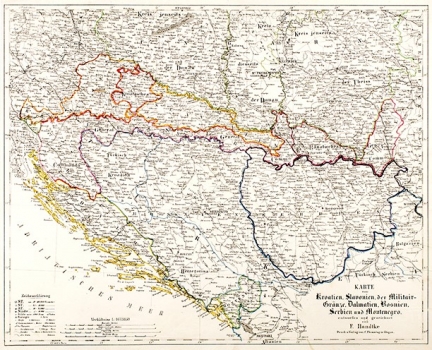
Original title: Karte von Kroatien, Slavonien, der Militar-Gränze, Dalmatien, Bosnien, Serbien und Montenegro
Publishing year: 1870
Place of publishing and publisher: Glogau
Format: 33,3 x 41 cm
Technique: Lithograph, partialy coloured boundary lines
The map shows Croatia, Bosnia and Serbia in the time before the Military Border (1873) and before the Austro-Hungarian occupation of Bosnia 1878. The Croatian, i.e. Slavonia Generalate of the Military Border in the East stretches all the way to Novi Sad, where Banat Generalate begins and, in the west, includes Karlovac and Lika all the way to the sea. The map also shows the so-called Turkish Croatia between Banja Luka and Bihać, and Sava River in the north and the mountains of Glamoč in the south. The map is interesting because it shows the political situation that completely changed in the near future by the abolition of the Military Border and the annexation of Bosnia.
FLEMMING, CARL
Carl Flemming, German printer and publisher who worked in Glogau (now in Poland) and in Berlin around the turn of the 19th/20th century. He issued regional maps of all the continents. All the maps issued by Flemming are printed by lithography.
