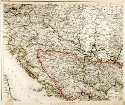
HILDENBURGHAUSEN: CROATIA, BOSNIA AND SERBIA
Inventory number 385
Author: HILDENBURGHAUSEN
Original title: Europäische Türkey in IV Blättern
Publishing year: 1849
Place of publishing and publisher: Hildenburghausen
Format: 33 x 41 cm
Technique: Partially coloured lithograph
This general map was published in the Meyer Hand Atlas, which dates from 1843 to 1860 and contained 170 maps of the entire world. The map shows Croatia and the Military Krajina, Austrian Dalmatia with Dubrovnik, Turkish Bosnia with the exit to the sea at Pelješac, and Serbia, which has acquired autonomy but, in the south, reaches only Aleksinac. The map is typical of the middle of the 19th century and the art of using colour is very informative.
HILDENBURGHAUSEN
