GASTALDI, GIACOMO JACOPO: A NEW MAP OF DALMATIA
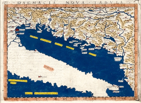
This Gastaldi’s map of Dalmatia, notable also as the first to name Dalmatia in its title, is form Gastaldi’s edition of Ptolemy's Geography published in Venice by Giovanni Battista Pedrezen, in 1548, as one out of the group of so called “tabule nove” subsequently added to the original maps by Ptolemy. This map is distinctive by being coloured which with that maps was rarely the case. It shows the land area that was in previous editions covered by the “Fifth Map of Europe” by Ptolemy. The map illustrates the region comprising the eastern Adriatic coast from the bay of Trieste and the river Drim in the south to the rivers Danube and Drau in the north. Despite the fact that Gastaldi corrected many mistakes, while copying from Ptolemy’s original, there are still many inaccuracies carried over. The whole map image is elongated in the east-westerly direction. The waterways are unrecognisable, and the coastal and insular outlines also show numerous deformities. The topography is presented arbitrarily. Gastaldi omitted to represent on his map the Dinaric Alps featured in the central position in Ptolemy’s original. The next issue of this map appeared in 1561 in the Ruscelli’s edition of Ptolemy’s Geography as a New Map of Slavonia (Tavola nuova di Schiavonia). “
GASTALDI, GIACOMO JACOPO
