FLEMMING, CARL: MAP OF DALMATIA
Inventory number 346
Author: FLEMMING, CARL
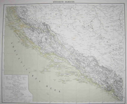
Original title: Königreich Dalmatien
Publishing year: 1876
Place of publishing and publisher: Glogau
Format: 32 x 48 cm
Technique: Partially coloured lithograph
This map was published in the 6th edition of the «Hand-Atlas». It shows Dalmatia as it was during the period of the second Austrian administration (1813-1918), immediately preceding the Congress of Berlin (1878) by the decision of which Austro-Hungary obtained a mandate to govern Bosnia (on the map Bosnia is still identified as making part of the Ottoman empire). It is a very detailed map of Dalmatia showing its settlements and basic network of streams and rivers with schematic representation of relief. Some Italian maps obviously served as sources for this map as some place names, especially island names, are italianized. The title is above the top margin edge.
FLEMMING, CARL
Carl Flemming, German printer and publisher who worked in Glogau (now in Poland) and in Berlin around the turn of the 19th/20th century. He issued regional maps of all the continents. All the maps issued by Flemming are printed by lithography.
