FLEMMING, CARL: MAP OF DALMATIA AND MONTENEGRO
Inventory number 198
Author: FLEMMING, CARL
Original title: Dalmatien und Monte Negro
Publishing year: 1870
Place of publishing and publisher: Glogau
Format: 33 x 40 cm
Technique: Partially coloured lithograph
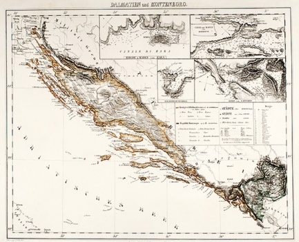
The map illustrates all of Dalmatia within the borders as they were when being part of the Habsburg Monarchy, which coincide with its present-day borders. As the map was produced following the topographic survey of Dalmatia carried out during the 30s and 40s of the 19th century by the Habsburg topographical engineers, it shows the accurate outlines of Dalmatia and its many islands. The relief is presented by applying a new technique - cross-hatching introduced by Habsburg military topographers. Along the map’s margin additional maps are featured representing the port of Zadar, the Channel of Šibenik, the Bay of Boka Kotorska and the Bay of St. Juraj on the island of Vis.
FLEMMING, CARL
Carl Flemming, German printer and publisher who worked in Glogau (now in Poland) and in Berlin around the turn of the 19th/20th century. He issued regional maps of all the continents. All the maps issued by Flemming are printed by lithography.
