JANSSONIUS, JAN: MAP OF KARST, CARNIOLA, SLOVENIAN MARK AND ISTRIA
Inventory number 256
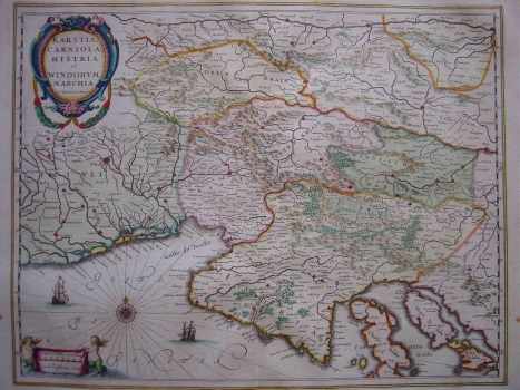
Original title: Karstia, Carniola, Histria et Windorum Marchia / Gerhard Mercator
Publishing year: 1635
Place of publishing and publisher: Amsterdam
Format: 37 x 49 cm
Technique: Coloured copper engraving
This Mercator’s map shows the Istrian peninsula with the Golf of Kvarner, Friuli, Karst, Carniola and Slovenian Mark. This is in fact the re-work of an earlier Mercator’s map called «Forum Julium..» dated 1589. This example was issued by the Dutch publisher Jan Janssonius, in 1635, in the Mercator-Hondius «Atlas Minor». The outline of Istria is quite defective. The course of the rives Raša, Mirna, Dragonja and the channel of Lim labeled as «Leme fl.» i.e. also identified as a river are indicated. In the inland zone of Istria the mountainous character of Ćićaria and Gorski kotar are highlighted. The title is in the upper left corner in an oval Renaissance cartouche. A mileage scale given in Italian miles is contained in a small cartouche held by two cherubs is placed in the lower left corner.
JANSSONIUS, JAN
After Henricus Hondius death, the work was continued by JAN (JOHANN) JANSSONIUS (1588-1664), a Dutch cartographer and publisher who edited as well new editions of the Atlas Mercator-Hondius. In 1633, he became related to Henric Hondius by marriage. As Hondius possessed Mercator's engraving plates, they collaborated on new editions of the Mercator's atlas. In 1633 they published the second edition of the Atlaa Mercator-Hondius. The most important work of Jan Janssonius is the atlas "Theathre du Monde" published in 1639 in three volumes. Due to the fact that it was regularly revised and expanded its 1662 version comprised as much as 11 volumes. In 1694 Peter Schenk (approx. 1645-1715) bought Janssonius's engraving plates.