JANSSONIUS, JAN: MAP OF NORTHERN DALMATIA
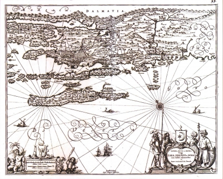
This map of Northern Dalmatia including Zadar and Šibenik area and the town of Nin, is an updated and revised issue of Kolunić's maps of Zadar and Šibenik hinterland, published over the years in various editions printed by Dutch publishers, from Ortelius and Mercator to Janssonius and Peter Schenk. This map exhibits a strong Mercator's influence reflected in the characteristic form of writing, as well as in its wind rose and sailing vessels design. This map was published in some of Janssonius's atlases (it bears the ordinal No. 99), most probably in the "Novus atlas sive theathrum orbis terrarum", which also included another famous map that refers to the Croatian lands - Magini's map "Istria olim Iapidia". This map is historically very interesting because in the inland zone of Zadar the boundaries with the Ottoman Empire in the inland zone of Zadar are shown as established in 1536 and 1570. The first line of demarcation indicated was fixed between the Ottoman Empire and the Republic of Venice just before the first Venetian-Turkish War in the course of which the Venetians retreated from Benkovac, Nadin and Vrana. After the Peace Treaty of 1540 made with the Turks, the Venetians were forced out of the region that extends between the rivers Neretva and Cetina, with the exception of the town of Omiš. The other demarcation line marks the boundary as established shortly before the second Venetian-Turkish War, also called the Cyprus War, at the end of which the Venetians recovered small peaces of Zadar and Šibenik inland zones granted by the Turks in compensation for the lost Cyprus. In the lower right corner of the map there is a very decorative cartouche depicting Turkish and Venetian solders and in the lower left corner a mileage scale expressed in Italian and German miles is featured in a cartouche adorned with the symbols of the Venetian Republic - Doge's cap and the Venetian Lion.
JANSSONIUS, JAN
