BLAEU, GUILIELMUS: MAP OF SLAVONIA, CROATIA, BOSNIA AND PARTS OF DALMATIA
Inventory number 66
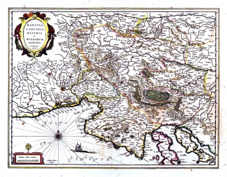
Original title: Karstia, Carniola, Histria et Windorum Marchia/ Geraardum Mercatore Auctore
Publishing year: 1662
Place of publishing and publisher: Amsterdam
Format: 39 x 50 cm
Technique: Partially coloured copper engraving
The map of Karstia, Carniola, Istria and of Slovenian Mark of Gerhard Mercator was first issued in Mercator's atlas of 1589 entitled "Forum Iulium…". This map was issued later on by many other Dutch publishers. Here ts issue by Johann Blaeu published in 1662 in his atlas "Atlas Maior" can be seen. As regards the Croatian lands are to be seen the Istrian peninsula with the Gulf of Kvarner. The representation of Istria is quite inaccurate. In the inland regions of Istria the mountain character of the regions of Ćićarija and Gorski kotar is clearly presented. A Renaissance cartouche in the upper left corner contains the title. A mileage scale in Italian miles (Milliaria Italica communia) is easily noticeable in the lower left corner of the map. To the left of the scale stands the inscription "GuilielmBleaeu excudit" who incised the map's copper plate. Above the scale is a drawn of the Globe, symbol of the cartographer's house of Blaeu family.
BLAEU, WILLEM
After Ortelius' death, his printing house continued under direction of GUILIELMUS BLAEU (1571-1638), a great Dutch cartographer and publisher who reissued several editions of Ortelius' atlases which he had revised and added some more maps. He had begun its career in Amsterda where at first he centered his activity in construction of measuring instruments and globe model producing. In 1599 he opens his workshop in Amsterdam. He inherited Ortelius' copper plates, so he was able to start as early as from the beginning of the 17th century with publishing and enlarging of the original Ortelius' atlas. From 1629 on, Blaeu's printing house came into possession of the Hondious' printing plates too. While he was continuing to publish Ortelius' and Hondius' plates, in 1629, Blaeu issues the first atlas of his own that included, of course, a number of maps made by foreign cartographers. But, beside Mercator-Hondius plates, Blaeu made 17 plates by himself. The summa of his work is represented in his atlas "Novus Atlas" of 1634, with its four new editions of 1635. His sons, Cornelius (approx. 1610-1648) and Johannes (1596-1673) continue with their father's work Johannes Blaeu publishes in 1649 his edition of "Atlas Blaviane" in 6 volumes, in 1662 "Atlas Maior" in 11 volumes and in 1663 "Le Grand atlas ou Cosmographie Blaviana" in 11 volumes. In 1638 Johannes Blaeu became a cartographer at the Dutch East India Company, and upon that his workshop develops into a modern cartographic factory. Blaeu's printing house was destroyed in the fire in 1672. A minor part of copper engraving plates that left acquired a Dutch de Witt family.