MAP OF HVAR
Inventory number 585
Author: CORONELLI, VINCENZO MARIA
Original title: Liesina
Publishing year: 1702
Place of publishing and publisher: Venezia
Format: 13 x 17 cm
Technique: Copper engraving
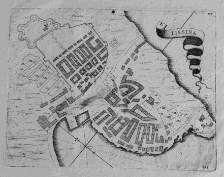
This graphic of the fortified town and port of Hvar was published in Coronelli's isolario Mari golfi, isole, spiaggie… (Small Isolario) in Venice around 1702. Hvar, as one of the key ports and naval strongholds on the eastern Adriatic Venetian estate, was shown on several maps from the mentioned atlas of the official Venetian cartographer. In the town itself, visualized in a ground plan perspective, blocks of houses and sketches of fortifications on the mainland side of the town are indicated. The ribbon title cartridge is in the upper right corner. The compass rose is located in the area of the port itself. Page number 171 is printed in the lower right corner.
CORONELLI, VINCENZO MARIA
VINCENZO MARIA CORONELLI (1650-1718). He was the most famous Italian cartographer from the period of the Venetian Republic. He established the society of geographers "Accademia degli Argonauta", one of the oldest in the world. In his cartographer's workshop in Venice he gathered a number of illustrators and cartographers. The Senate of Venice supported their work with large amounts of money, and Coronelli was the first cartographer who had a reputation as an official geographer of the Venetian Republic. His maps, a part of their strategic and economical importance, were also often used as powerful instruments of exaltation of Venice and its victories over theTurks. In delineation of boundaries Coronelli usually indicates the state of things as it was before the Turkish conquests, not recognizing Turkish possessions in Dalmatia. At the same time on all his maps he noted next to various places the names of the Venetian conquests during the Morean war. In the period nearing the end of the 17th century, his maps were used by all the state services of the Venetian Republic. Coronelli was the author of the best Venetian atlases: "Isolario dell'Atlante Veneto" issued in two volumes, also named "The Great Isolario". The other is "Mari, Golfi, Isle, Spiaggie, Porti, Citta…" issued in four volumes named "The Small Isolario" that comprises over 100 port and fortress plans including as well a number of map images of the Croatian coast.
