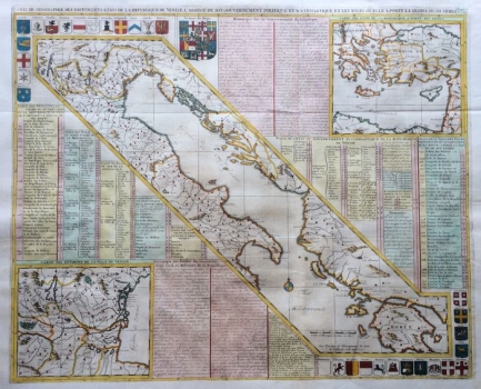
MAP OF THE LAND POSSESSIONS OF THE VENETIAN REPUBLIC
The large geographical sheet consists of three maps with a large number of lists and map keys. All of them refer to the land and overseas possessions of the Venetian Republic depicted on the maps, with texts on the organization of civil, ecclesiastical and military administration in these areas. In the bottom left corner is a map of Terra ferma, the direct hinterland of the Republic, which borders the land owned by the Papal States south of Ravenna and extends to Friuli in the north. The map in the upper right corner shows the Venetian possessions in Asia Minor, while the large central diagonally positioned map shows the Venetian overseas possessions along the Adriatic and Ionian Seas. Therefore, these are thematic maps of land possessions, and there is even the land border of the Venetian territory but, in addition to the dominant subject, the maps also summarize the total geographical inventory in the mentioned area, in accordance with the pre-modern fashion. The orientation is regular, as evidenced by the compass rose marking north towards the top of the map. The Dutch author expressed the graphical scale of the big map in German miles. In the corners of the entire geographical sheet are heraldic coats of arms of the Doge and his 30 countries, including the coat of arms of Dalmatia in the upper and Istria and Zadar in the lower corner. The map is very educational and it was published in the work Atlas Historique ..., which combined a seven-volume-long rich historical, geographical, genealogical, topographic and cartographic heritage and production of influential French cartographers in the first decades of the 18th century, above all Guillaume de l'Isle. Henry, his father, who was also named Henry, and his brother, Zacharie Chatelain, worked on the atlas, with the help of French cartographer Nicolas Gueudeville.
CHATELAIN, HENRI ABRAHAM
