BLAEU, GUILIELMUS: MAP OF THE VENETIAN POSSESSIONS IN ITALY AND ISTRIA
Inventory number 511
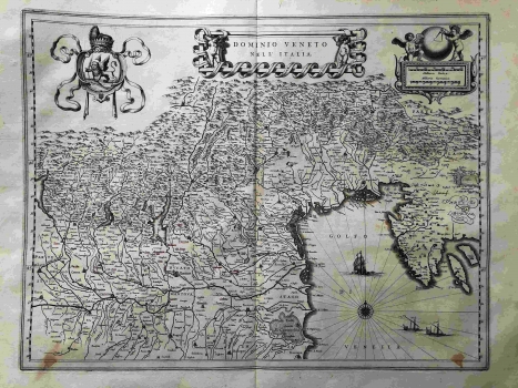
Original title: Dominio Veneto nell' Italia
Publishing year: 1634
Place of publishing and publisher: Gotha
Format: 38 x 49,7 cm
Technique: Partially coloured copper engraving
The map depicts properties in northern Italy, stretching from the Venetian administration with an early-modern expansion in the hinterland, to Ravenna in the south and Tyrol in the north. Larger cities such as Verona, Vicenza, Padua, Ravenna, Brescia, Parma or Cremona are shown. The map also includes the entire Istria, although under the Venetian rule it was only the western part of the peninsula, while the Pazin earldom was a Habsburg property on the eastern half of the peninsula from the 12th century. The map is dominated by the very rich and branched riverbed of the River Po. The map most likely originated from the German edition of the Atlas Novus published in two volumes. The map is very richly decorated. The cartouche in the shape of a shield with an outspread lion, the symbol of the Venetian Republic, is in the left corner. The title cartouche is decorated with a drapery in the shape of a banderol with the names of important cities. Richly decorated graphical scale expressed in Italian and German miles is in the upper right corner. The North Adriatic is decorated with sailboats and a large compass cross.
BLAEU, WILLEM
After Ortelius' death, his printing house continued under direction of GUILIELMUS BLAEU (1571-1638), a great Dutch cartographer and publisher who reissued several editions of Ortelius' atlases which he had revised and added some more maps. He had begun its career in Amsterda where at first he centered his activity in construction of measuring instruments and globe model producing. In 1599 he opens his workshop in Amsterdam. He inherited Ortelius' copper plates, so he was able to start as early as from the beginning of the 17th century with publishing and enlarging of the original Ortelius' atlas. From 1629 on, Blaeu's printing house came into possession of the Hondious' printing plates too. While he was continuing to publish Ortelius' and Hondius' plates, in 1629, Blaeu issues the first atlas of his own that included, of course, a number of maps made by foreign cartographers. But, beside Mercator-Hondius plates, Blaeu made 17 plates by himself. The summa of his work is represented in his atlas "Novus Atlas" of 1634, with its four new editions of 1635. His sons, Cornelius (approx. 1610-1648) and Johannes (1596-1673) continue with their father's work Johannes Blaeu publishes in 1649 his edition of "Atlas Blaviane" in 6 volumes, in 1662 "Atlas Maior" in 11 volumes and in 1663 "Le Grand atlas ou Cosmographie Blaviana" in 11 volumes. In 1638 Johannes Blaeu became a cartographer at the Dutch East India Company, and upon that his workshop develops into a modern cartographic factory. Blaeu's printing house was destroyed in the fire in 1672. A minor part of copper engraving plates that left acquired a Dutch de Witt family.