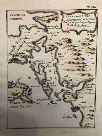
BELLIN, JACQUES NICOLAS: MAP OF ELAPHITI ISLANDS
As with the other maritime charts by hydrographer Bellin, the most important useful navigational data on land access from the sea side are represented on this chart. This map of Dubrovnik and the coast north of the city includes the southwest part of the Pelješac peninsula (Presque Isle de Sabionchello) and a part of the island of Mljet. Important anchors in the Elaphiti Islands canal are mapped and sea depth data are recorded. The particularity of this map is that the important information on this map is less present than on other Bellin's maps. Only two settlements are labelled, northeast of Šipan (Luc, 3-6 brasses) and northeast of Lopud (I. Mezza, 1-3 brasses). The city of Dubrovnik is represented by an oversized red plan of prominent fortifications, while smaller fortifications are drawn up at Ston and Mali Ston (Stano le Petit). Komolac (Vestige dela Cittée de Cumulax) was recorded at the top of Rijeka Dubrovačka. There are no indications of boundaries with the Ottomans in the Dubrovnik hinterland, although the map was created at the end of the Venetian administration. The inland is not shown in more detail, but the relief is only schematically illustrated with scattered molehills and arbitrarily placed symbols indicating rare vegetation. The title cartouche with the graphic scale (Echelle de 2 Lieues) is located at the top right corner. A note on the number of copper plate (Pl. XXII.) is above the map frame.
BELLIN, JACQUES NICOLAS
