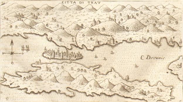
À VAREA, LASOR: VIEW OF TROGIR
The view shows the town of Trogir and the island of Čiovo in the foreground. They are connected to the mainland with bridges. Raffaello Savonarola particularly emphasized the city ramparts and church towers, for example the Kamerlengo tower or the church bell tower of St. John (sv. Ivan), as well as the churches in the bay of the Kaštela Littoral. The compass cross is next to the left edge of the view. It points out that the north is at the top of the map. The title is below the upper edge, and from the toponyms the author recorded C Dreunit in the Trogir Channel. There are several fortifications on the surrounding hills in the hinterland. Orography of the coast and the islands is indicated by schematized and oversized molehills, while the characteristic morphology of Mosor and Kozjak is omitted. Savonarola produced the map in co-operation with Giacomo Franco. This is a later rendition of older representations of the same space as the map which Natale Bonifacio produced for Camocio's Isole famose of 1571 or maps of Domenico Zenoi and Donato Berteli from 1574. Interestingly, the author from Padova reduced the geographic content he used as a template, so his map is more modest with inventory, such as toponyms.
A VAREA, LASOR
