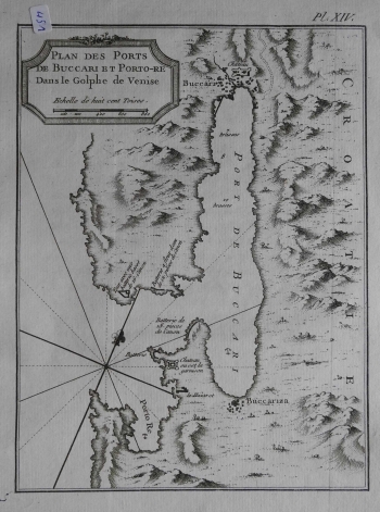
BELLIN, JACQUES NICOLAS: MAP OF THE BAY OF BAKAR
The map shows the Bay of Bakar (Buccari) with anchors at Bakarac (Buccarizza) and Kraljevica (Porto Re). The depths on the approach to the port of Bakar are also indicated. This is also stated in the title cartouche. The map was created at the end of the Venetian administration. The inland of the island was not interesting to the author and there is only a schematic representation of relief using scattered molehills. Apart from the main settlements, the toponyms of bays, gulfs, and capes are missing. The orientation is northwest, so the map is rotated in the east. The compass rose with 16 segments is located on the left edge of the map. Hydrographer Bellin considered batimetric data (expressed in fathoms, one fathom being 6 feet long) the most interesting as theyare very important navigational data, as well as the distribution of weapons, that is, fortresses and batteries, located on both banks of the approach channel. The southern coast is particularly fortified, with Batterie de 18 pieces de Canon and Chateau ou est la Garnison. The title cartouche with the graphic scale (Echelle de huit cent Toises) is in the top left corner. A note on the number of the plate in the atlas (Pl. XIV.) is above the map frame.
BELLIN, JACQUES NICOLAS
