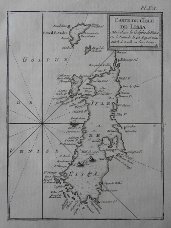
BELLIN, JACQUES NICOLAS: MAP OF VIS
Bellin's map depicts the outline and a portion of the island's interior under the Venetian administration (before the signing of the Treaty of Campo Formio in 1797), with several islands and islets (Biševo, Brusnik and Sv. Andrija and Mali Barjak). They are drawn west from the port of Komiža (Knezra Port), but because the map is west-oriented, they are located at the top of the map. There is a large field in the interior with the elevations of S. Vito Bgliso near Pliško Polje, and on the southern side of the island is Stiniva Bay (Stiniua V.). The Vis harbour on the north side of the island is marked as Port S. Georges. Along the left edge, there is a compass rose with 16 segments and a lily that shows north. Bellin was a marine chartographer, a hydrographer (the main cartographer of the French navy and king) and the first engineer of the French Hydrographic Office. He paid special attention to the coast line and approaching the island from the sea with a series of coves, bays, isles and other navigational details. The cartouche with the title, geographic latitude (Par la Latitude de 54. Deg.15.min.) and the graphic scale expressed in sea miles is in the upper right corner. A note with the number of the plate in the atlas (eg XIX.) is located above the map frame.
BELLIN, JACQUES NICOLAS
