BELLIN, JACQUES NICOLAS: MAP OF DALMATIA FROM ROGOZNICA TO STON
Inventory number 282
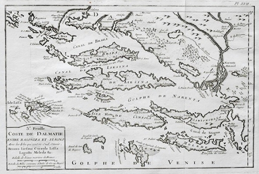
Original title: Coste de Dalmatie entre Ragogoniza et Stagno
Publishing year: 1771
Place of publishing and publisher: Paris
Format: 20,5 x31,8 cm
Technique: Copper engraving
As indicated by the title, the map shows a part of Dalmatia extending between Rogoznica in the west and Ston in the east. So that, besides southern Dalmatia, the map image includes a part of the territory of the Republic of Dubrovnik with the islands of Mljet (Meleda) and Lastovo (Lagosta), as well as the peninsula of Pelješac (Sabioncello) that at that time formed part of the Republic of Dubrovnik. In the area shown all the main settlements and ports are identified. Particularly interesting is the representation of the delta of the river Neretva and that of the confluence of the river Cetina with the sea. As marine cartographer Bellin placed a special emphasis on the representation of the coastline, bays and reefs considered as critical to safe navigation in these parts of the Adriatic Sea. The map’s title and the mileage scale are in the lower left corner within a plain cartouche. This map was published in one of the editions of Bellin’s atlases.
BELLIN, JACQUES NICOLAS
Bellin, Jacques Nicolas (1703-1772) was a famous French cartographer who spent many years in the French Hydrograph Service. In 1772, Bellin was appointed the first « Ingenieur Hydrographe de la Marine » (Dépôt des Cartes et Plans de la Marine), as well as later in life “Hydrograph to the King”. As the first French marine cartographer, he made many maps. He is best known for his high quality sea charts of the French colonies, including those located in North America. Bellin’s other works include atlases out of which the most noted are: «Hydrographique Francais» in 2 volumes (1756-1765) and «Petit Atlas Francais» in 5 volumes (1763), republished in 1765 under the title «Petit Atlas Maritime». He engraved world maps for Abbe Prevost’s work «Histoire Generale des Voyages (1746-1757)». For their popularity and high esteem they enjoyed, many cartographers inserted his maps in their atlases long beyond Bellin’s life span.