BELLIN, JACQUES NICOLAS: MAP OF DALMATIA FROM ZADAR TO ŠIBENIK
Inventory number 281
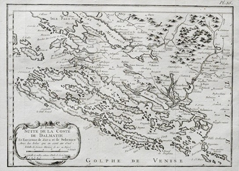
Original title: Suite de la Coste de Dalmatie et environs de Zara et de Sebenico
Publishing year: 1771
Place of publishing and publisher: Paris
Format: 20,3x28,2 cm
Technique: Copper engraving
The map shows inland and coastal areas and islands stretching between Novigrad to the west and Rogoznica to the east. Besides major settlements, Bellin included into his map the network of rivers, or more precisely the rivers of Krka and Zrmanja with their tributaries. The stylised relief is shown with scattered molehills. The area of Bukovica covered in bushes was illustrated with the symbol of shrub (this Dalmatian area covered with vegetation was especially valuable for grazing use). As on most maps of the time the Velebit channel is identified as the Channel of Morlacs (Canal de Morlacca). The title and the mileage scale of the map are in the lower left corner contained in a plain cartouche. This map was published in one of the editions of Bellin’s atlases.
BELLIN, JACQUES NICOLAS
Bellin, Jacques Nicolas (1703-1772) was a famous French cartographer who spent many years in the French Hydrograph Service. In 1772, Bellin was appointed the first « Ingenieur Hydrographe de la Marine » (Dépôt des Cartes et Plans de la Marine), as well as later in life “Hydrograph to the King”. As the first French marine cartographer, he made many maps. He is best known for his high quality sea charts of the French colonies, including those located in North America. Bellin’s other works include atlases out of which the most noted are: «Hydrographique Francais» in 2 volumes (1756-1765) and «Petit Atlas Francais» in 5 volumes (1763), republished in 1765 under the title «Petit Atlas Maritime». He engraved world maps for Abbe Prevost’s work «Histoire Generale des Voyages (1746-1757)». For their popularity and high esteem they enjoyed, many cartographers inserted his maps in their atlases long beyond Bellin’s life span.