BRUN (BRUNN), (MALTHE) CONRAD: MAP OF THE ILLYRIAN PROVINCES
Inventory number 396
Author: BRUN, CONRAD (MALTHE)
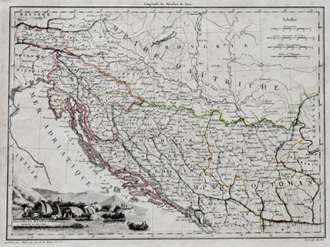
Original title: Provinces Illyriennes, Servie et Bosnie
Publishing year: 1812
Place of publishing and publisher: Paris
Format: 22 x 30 cm
Technique: Steel engraving
The map was published in the 'Atlas Complet' by a Danish cartographer who worked in Paris. The map faithfully displays the state after Napoleon’s occupation of territories from Istria to Kotor and accurately marks the delimitation with the Austrian and Ottoman empires.
BRUN, CONRAD (MALTHE)
BRUN (BRUNN), (MALTHE) CONRAD (1775-1826) was a Danish geographer, cartographer and publisher. After 1800 he published works in Paris, for example Atlas Complet (1812) or Geograph. Univ. (1816). He was especially interested in Napoleon’s conquests and the countries he had invaded, including the Illyrian provinces. In 1824 he published Traité de la légitimité considérée comme base du droit public de l'Europe chrétienne.
