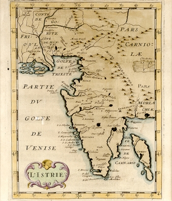
BRIET, PHILIPPE S. J.: MAP OF ISTRIA
Philip S.J. Briet Francuski (1601-1668), a notable French cartographer and publisher, born in Abbeville, who published several editions of atlases during the years of the 17th century and in that the work «Parallela Geographica Italiae Veteris et Nova» printed in Paris in the workshop of Sebastian and G. Cramosiy occupies a special place. This Briet’s work reappeared in several editions and this example comes from the 1635 issue. The map was based on Mercator’s maps of Istria after which Briet modelled his map and consequently the inaccuracies present on Mercator's maps are repeated on this map too (especially, as regards the representation of the island Cres shown as three separated islands and the lake of Cerkniško jezero enlarged in proportion). However, with regard to Mercator’s editions, the improvement is evident in the delineation of the contours of the Istrian peninsula now are much more accurate which reflects the influence of the Venetian and French cartographers and especially of their nautical charts (on the coastal zone of Istria more locations are identified, but little is shown in the inland zone). The title of the map is in the lower left corner within a Renaissance cartouche. Although the map has marked geographical grid degrees, there are no scales.
BRIET, PHILIP
