Hrvatski Deutsch English
Home Maps Authors a-e ALBRIZZI Città di Pola nella / Città di Capodistria
ALBRIZZI, GIAMBATISTA: VIEWS OF PULA AND KOPER

ALBRIZZI, GIAMBATISTA: VIEWS OF PULA AND KOPER

Inventory number 265
Original title: Città di Pola nella Provincia dell' Istra/ Anfiteatro di Pola/ Mausoleo di Pola/ Tempio antico di Pola/ Città di Capodistria Capitale della Provincia
Publishing year: 1727
Place of publishing and publisher: Venezia
Format: 14 x 22 cm
Technique: Copper engraving

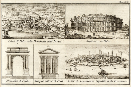
This graphic sheet comprises 5 views with four of them relating to the town of Pula and its characteristic structures dating back to the Antiquity, while the fifth view shows the town of Koper (in present-day Slovenia), the then seat of the Venetian province of Istria. The first view of the town of Pula features an identical map image as that made by Camoco in his isolario of 1571. In the town’s inland zone the ruins of the antique amphitheatre can be seen (ccoloseo antico), as well as the monastery of St. Michael. In front of the church the rests of antique structures are shown (ruine antiche). The Golf of Pula is drawn with many inaccuracies, as well as the southern peninsula in the front of Pula on which  Orlando’s turret and the church of St. Mary of Premantura are identified. The town is shown enclosed within the walls. The second view on this sheet shows the amphitheatre of Pula, the most noted antique monument of the town of Pula. It is shown outside the town walls on the hill of Kaštanjer. The amphitheatre of Pula is the sixth largest antique amphitheatre in the world.  The third view shows another noted Pula’s monument dating back to antiquity – the triumphal arch of  Sergeans built after the year 31 shown on the view inside the walls. On the fourth view we can see the front of the Temple of August built at the beginning of the first century. The fifth view shows Koper, also modeled after the view most probably made by the Šibenik native Božo Bonifačić for the Camoco’s isolario of 1571.

ALBRIZZI, GIROLAMO
ALBRIZZI, GIAMBATISTA (1698-1777), an Italian publisher from the 18th century. The two-volume Gerusalemme liberata (1745), which he published in collaboration with Giovanni Battista Piazzetta, is among his most famous works. He published the work Stato presente di tutti paesi e popoli del mondo naturale, politico, e morale, con nuove osservazioni, e correzioni degli antichi e moderni viaggiatori in Venice in 1753. His works are an important contribution to the Croatian cartography primarily because of his geographical map of Istria, Pula, Venetian Dalmatia, Osor, Kvarner and Šibenik. While some maps of the North Adriatic ports are marked by a relative imprecision of geographical data, Albrizzi based his depiction of Šibenik on Rota’s map of the same region. He also used Bonifaci’s maps, of Kopar or Osor for example, that the Šibenik native had created for Camoci’s isolario in 1571. This kind of temporal deviation confirms that he was inspired by older local masters, and the same can be seen in his depictions of cities and their surroundings which were predominantly characterised by the images of the Ottoman-Ventian War, even though the cities had already been under the Venetian rule since 1718, well before his works were created.
Print Friendly and PDF
Top