CORONELLI, VINCENZO MARIA: MAP OF THE REPUBLIC OF DUBROVNIK
Inventory number 163
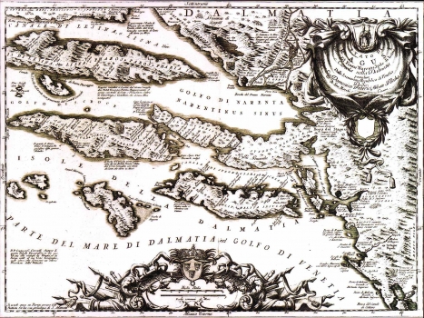
Original title: Stato di Ragusi, Bocca del Fiume Narenta, Isole di Lesina e Curzola nella Damlatia possedute Dalla Serenissima Republica di Venetia: dedicato All’ Illustrissimo Signor Domenico Federici, Abbate di Vaska, Consegliere di Sua Maestà Cesarea
Publishing year: 1692
Place of publishing and publisher: Venezia
Format: 45 x 62 cm
Technique: Copper engraving
The map of the Republic of Dubrovnik by Vincenzo Maria Coronelli was made upon request by the Republic's authorities that commissioned the famous Venetiean cartographer, in 1685. From the Republic of Dubrovnik Coronelli received the necessary descriptions and topographic data as well as 20 golden peaces in reword for the map produced. The map shows the territory of the Republic of Dubrovnik, which included the greater Dubrovnik area comprising the mouth of the river Neretva, the peninsula of Pelješac and the islands of Mljet and Lastovo. The islands of Hvar and Korčula are shown with a note saying that they formed part of the Venetian possessions and additionally identified with the Venetian coat of arms. The text set in next to some settlements gives information on the number of houses. The title of the map is in its upper right corner in a large baroque cartouche containing the coat of arms of the Republic of Dubrovnik. In the lower left corner we can see the publisher's note stating «si vende anco Parigi presso Gio. Battista Nolin con privilegio di Sua Maestŕ». A mileage scale, in Italian miles, is placed in a very decorative cartouche crowned by the coat of arms of Dalmatia.
CORONELLI, VINCENZO MARIA
VINCENZO MARIA CORONELLI (1650-1718). He was the most famous Italian cartographer from the period of the Venetian Republic. He established the society of geographers "Accademia degli Argonauta", one of the oldest in the world. In his cartographer's workshop in Venice he gathered a number of illustrators and cartographers. The Senate of Venice supported their work with large amounts of money, and Coronelli was the first cartographer who had a reputation as an official geographer of the Venetian Republic. His maps, a part of their strategic and economical importance, were also often used as powerful instruments of exaltation of Venice and its victories over theTurks. In delineation of boundaries Coronelli usually indicates the state of things as it was before the Turkish conquests, not recognizing Turkish possessions in Dalmatia. At the same time on all his maps he noted next to various places the names of the Venetian conquests during the Morean war. In the period nearing the end of the 17th century, his maps were used by all the state services of the Venetian Republic. Coronelli was the author of the best Venetian atlases: "Isolario dell'Atlante Veneto" issued in two volumes, also named "The Great Isolario". The other is "Mari, Golfi, Isle, Spiaggie, Porti, Citta…" issued in four volumes named "The Small Isolario" that comprises over 100 port and fortress plans including as well a number of map images of the Croatian coast.