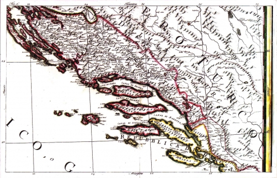
CASSINI, GIOVANNI MARIA: MAP OF DALMATIA
Inventory number 159
Author: CASSINI, GIOVANNI MARIA
Original title: Dalmazia, Tavola 6
Publishing year: 1792
Place of publishing and publisher: Roma
Format: 39 x 62 cm
Technique: Partially coloured copper engraving
This Cassini's map of Dalmatia formed part of his famous 15-sheet map of Italy “Carta generalle dell Italia”, published in Rome between 1790 and 1792. For that time period, this map was made at an exceptionally large scale. This sheet comprises almost the whole of Dalmatia together with the Republic of Dubrovnik. It features a very detailed network of settlements. The delineation of the Venetian-Ottoman border is indicated as it was after the Peace Treaty of Požarevac (1718) and the Peace Treaty of Svištov (1791). The outlet to the sea near Klek is clearly marked, as well as the most part of the Republic of Dubrovnik.
CASSINI, GIOVANNI MARIA
CASSINI, GIOVANNI MARIA, an Italian illustrator and copper-plate engraver. He was active in the second half of the 18th century in Rome. His most famous work is the atlas Nuovo atlante geografico universale, which had several editions in the period from 1792 to 1801. He became known worldwide thanks to his globuses.
