À VAREA, LASOR: VIEW OF THE TOWN OF KLIS
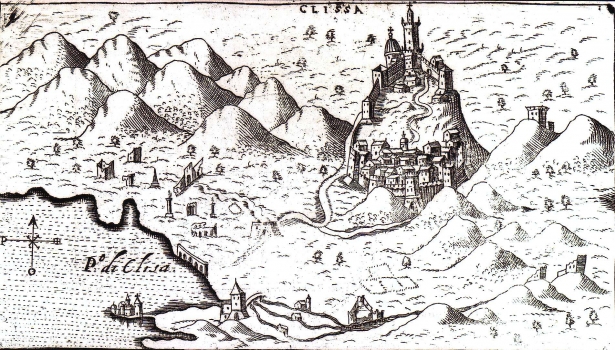
This town view of Klis was based on the earlier view made by Giovanni Francesco Camoccio in 1571. This issue, edited by Lasor à Varea, was published in the 1713 edition of his work “Universus Terrarum Orbis”. The view of Klis appeared on page 278. The only difference between this and Camoccio’s map relates to their title design that on Camoccio’s map is contained in a plain cartouche. This view shows Klis and its greater surroundings. The map image extends from the river Jadro, where the Castelo di Salona, as well as watermills set alongside the river and a Turkish castle in ruins can be seen. Along the Golf of Kašela the ruins of the antique Salona are identified, as well as the road leading from it towards Klis and connecting the fortress of Klis and the settlement in its suburb. From 1537 Klis was under Turkish rule. For that reason, besides by the fortification structures the town is dominated by the mosque and its minaret. The representation of the ranges of Kozjak and Mosor is completely fictitious. The ruins of buildings around Klis suggest destructions inflicted by numerous conflicts.
A VAREA, LASOR
