BLAEU, GUILIELMUS: MAP OF SLAVONIA, CROATIA, BOSNIA AND PARTS OF DALMATIA
Inventory number 104
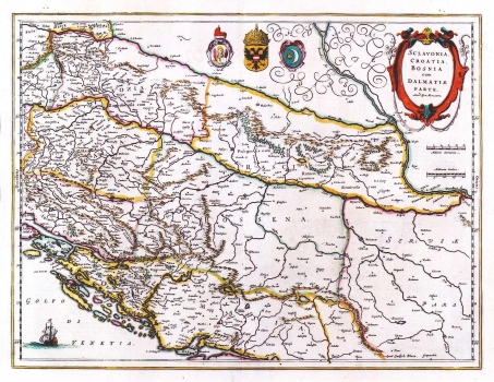
Original title: Sclavonia, Croatia, Bosnia cum Dalmatiae parte/ auctore Gerhard Mercatore
Publishing year: 1648
Place of publishing and publisher: Amsterdam
Format: 30 x 50 cm
Technique: Partially coloured copper engraving
Mercator's map of Slavonia, Croatia, Bosnia and parts of Dalmatia went through many issues in various Dutch atlases, after its first publication in 1589. These editions differ only in cartouche design. This issue was first published in Blaeu's "Atlas Novus" of 1648. As most Dutch maps of the time, this map shows the Croatian lands within not quite accurate medieval state boundaries. The frontier between Croatia and Bosnia is demarcated somewhat easterly from the river Una, Dalmatian borders are pushed deeply inland so that it comprises the whole Herzegovina. Zagreb is indicated twice, once as Agram and then as Zagreb. Decorative details include coat of arms of the Republic of Venice, of the House of Habsburg and of the Ottoman Empire. A mileage scale is in German and Italian miles.
BLAEU, WILLEM
After Ortelius' death, his printing house continued under direction of GUILIELMUS BLAEU (1571-1638), a great Dutch cartographer and publisher who reissued several editions of Ortelius' atlases which he had revised and added some more maps. He had begun its career in Amsterda where at first he centered his activity in construction of measuring instruments and globe model producing. In 1599 he opens his workshop in Amsterdam. He inherited Ortelius' copper plates, so he was able to start as early as from the beginning of the 17th century with publishing and enlarging of the original Ortelius' atlas. From 1629 on, Blaeu's printing house came into possession of the Hondious' printing plates too. While he was continuing to publish Ortelius' and Hondius' plates, in 1629, Blaeu issues the first atlas of his own that included, of course, a number of maps made by foreign cartographers. But, beside Mercator-Hondius plates, Blaeu made 17 plates by himself. The summa of his work is represented in his atlas "Novus Atlas" of 1634, with its four new editions of 1635. His sons, Cornelius (approx. 1610-1648) and Johannes (1596-1673) continue with their father's work Johannes Blaeu publishes in 1649 his edition of "Atlas Blaviane" in 6 volumes, in 1662 "Atlas Maior" in 11 volumes and in 1663 "Le Grand atlas ou Cosmographie Blaviana" in 11 volumes. In 1638 Johannes Blaeu became a cartographer at the Dutch East India Company, and upon that his workshop develops into a modern cartographic factory. Blaeu's printing house was destroyed in the fire in 1672. A minor part of copper engraving plates that left acquired a Dutch de Witt family.