BLAEU, GUILIELMUS: MAP OF ISTRIA
Inventory number 82
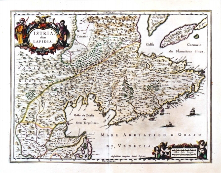
Original title: Istria olim Japidia / Willem Guiliemus Blaeu
Publishing year: 1663
Place of publishing and publisher: Amsterdam
Format: 38 x 50 cm
Technique: Copper engraving
This map is from the IX volume of the great Blaeu's atlas "Le Grand atlas ou Cosmographie Blaviana". The first edition of this map, bearing the same title, appeared in Venice in Giovanni Mafini's edition of 1620 (ref. cat. No. 115), which had as its source the map of Istria made by Petar Kopinić (ref. catalogue No. 59). The map shows the Istrian peninsula with parts of the Gulf of Kvarner. Magini effectuated some corrections on the original Kopić's map, which was followed by Blaeu. The town of Rijeka misplaced by Kopić in the northeastern Istria, was located correctly. The position of the Bay of Bakar is also corrected. The forests were indicated around Dragonja and Mirna and in the upper part of the Channel of Lim. The topography is again shown with shaded molehills. The title is shown in an oval cartouche. On the cartuche sits a great lion - symbol of the Republic of Venice, and at the left and right sides of the cartouche are armored soldiers as symbolic guards of the Republic. The whole cartouche symbolizes the domination of Venice over Istria.
BLAEU, WILLEM
After Ortelius' death, his printing house continued under direction of GUILIELMUS BLAEU (1571-1638), a great Dutch cartographer and publisher who reissued several editions of Ortelius' atlases which he had revised and added some more maps. He had begun its career in Amsterda where at first he centered his activity in construction of measuring instruments and globe model producing. In 1599 he opens his workshop in Amsterdam. He inherited Ortelius' copper plates, so he was able to start as early as from the beginning of the 17th century with publishing and enlarging of the original Ortelius' atlas. From 1629 on, Blaeu's printing house came into possession of the Hondious' printing plates too. While he was continuing to publish Ortelius' and Hondius' plates, in 1629, Blaeu issues the first atlas of his own that included, of course, a number of maps made by foreign cartographers. But, beside Mercator-Hondius plates, Blaeu made 17 plates by himself. The summa of his work is represented in his atlas "Novus Atlas" of 1634, with its four new editions of 1635. His sons, Cornelius (approx. 1610-1648) and Johannes (1596-1673) continue with their father's work Johannes Blaeu publishes in 1649 his edition of "Atlas Blaviane" in 6 volumes, in 1662 "Atlas Maior" in 11 volumes and in 1663 "Le Grand atlas ou Cosmographie Blaviana" in 11 volumes. In 1638 Johannes Blaeu became a cartographer at the Dutch East India Company, and upon that his workshop develops into a modern cartographic factory. Blaeu's printing house was destroyed in the fire in 1672. A minor part of copper engraving plates that left acquired a Dutch de Witt family.