WALDSEEMÜLLER, MARTIN: THE FIFTH MAP OF EUROPE
Inventory number 269
Author: WALDSEEMÜLLER, MARTIN
Original title: Europa V Tabula
Publishing year: 1541
Place of publishing and publisher: Vienne
Format: Europa V Tabula
Technique: Colored woodcut
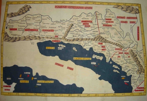
This Waldseemüller’s edition of Ptolemy’s Fifth map of Europe was published in Vienn, province of Dauphine, in 1541. The maps was issued by the publishers Melchior and Gaspar Treschel. It shows the Roman provinces of Rethia, Vindelicia, Noric, Lower and Upper Pannonia, Illyricum and Dalmatia. The map is almost identical to a map edited by Münster. This is an example of the famous Ptolemy’s Fifth map of Europe in this case published after its final elaboration by Martin Waldseemüller.
WALDSEEMÜLLER, MARTIN
MARTIN WALDSEEMÜLLER (1470-1521) - a cartographer from Alsace. He had his schooling in Freiburg and exercised cartographic activities in St. Dieu within a frame of French cartographic traditions. On his world map of 1507 he was the first in using the word America. He issued several editions of Ptolemy's Geographia, which he published in Strassburg (1513, 1520). Some of his Ptolemy's editions appeared after his death (1525, 1535 in Lyion and in 1541 in Vienne).
