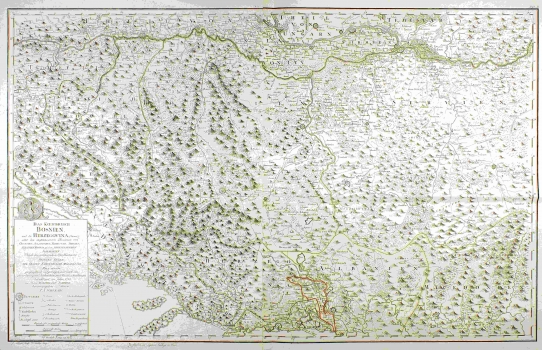
SCHIMEK (SCHIMECK), MAXIMILIAN: MAP OF BOSNIA AND THE SURROUNDING COUNTRIES
By the time of the breaking out of the last Austrian-Turkish war, the Habsburg cartographers were already far advanced in their mapping of the Bosnian territory. Most of them were military topographical engineers working undercover. This map of Schimek is one of the rare regional maps of Bosnia made for civilian purposes. Military maps put aside, after the map of Bosnia by Cantelli and besides the map of Bosnia of Schütz, this one continued to be the best civilian map of Bosnia as long as until the beginning of the 19th century. J. Alberti incised the map image in cooper and F. Müller executed the calligraphy. The map by Schimek was created only one year after the publishing of his work entitled “Politische Geschichte des Königreichs Bosnien und Rama vom Jahre 1867 bis 1741, printed in Vienna at Christian Friedricha Wappler's. The map shows Bosnia and Herzegovina as still being part of the Ottoman Empire. Besides Bosnia and Herzegovina, the map includes most part of Dalmatia, The Republic of Dubrovnik, as well as parts of Croatia, Slavonia, Serbia, Albania and Macedonia. Within the territory of Bosnia the area of the so called «Turkish Croatia» is individually delineated comprising the land area laying between the rivers Una and Vrbas which before the Turkish intrusion formed part of the Croatian Kingdom. The map gives especially rich supply of place names. All the settlements shown are classified whether as a fortress, town, market place or village, giving us thus some insight into the hierarchical structure of settlements. This is one of the rare maps dating back form the 18th century featuring the network of traffic communications (until the 18th century maps didn’t feature roads). In the sub-title of the map of Schimek sources of data are provided on which the map was based and that precisely are the cartographic works produced in the tome of Prince Eugen, Count Khevenhüller, Counts Marsiglio and Palavicini. Although not mentioned in the sub-title, the characteristic cartographic map’s style suggests that Schimek was acquainted with some more recent works such as the map of Bosnia of de Rebain of 1750 and map by Briffaut made in 1738.
SCHIMEK, MAXIMILIAN
