SANSON, NICOLAS: MAP OF THE ADRIATIC SEA
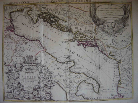
This Coronelli-Sanson’s map published in the atlas of Hubert Jailolt “Atlas Noveau…” made at the request of Louis XIV King of France displays the dedication to the noted Venetian cartographer Coronelli on whose earlier map it was based. The map shows the Adriatic Sea and the Republic of Venice, comprising all of Dalmatia under its administration at that period. The Adriatic Sea is identified as “Golf of Venice” (Golfe de Venise) being that at one time its customarily used name. In accordance with its title, the author placed his greatest attention to the representation of ports and promontories. The concept that is also confirmed by the plans of all major Adriatic ports featured around the title cartouche including the following Croatian ports: Dubrovnik (Ragusa), Šibenik (Sibenik), Trogir (Trau), Zadar (Zara), Korčula (Curzola), Pula (Pola), Split (Spalato), Senj (Segna) i Hvar (Liesina). Despite the fact that the map has been primarily intended for nautical use, the island and coastal profiles of the Croatian side of the Adriatic are shown with many faults. Particular attention was given to the map’s graphic design. The title is enclosed within a sumptuous baroque cartouche embellished with the plans of towns out of which the most prominent is the view of Venice. The mileage scale is in the upper right corner of the map also contained in a very decorative cartouche displaying the flags of the defeated countries (Ottoman) and the Venetian lion as its dominant features.
SANSON, NICOLAS
