SCOLARI, STEFANO: MAP OF DALMATIA AND ALBANIA
Inventory number 453
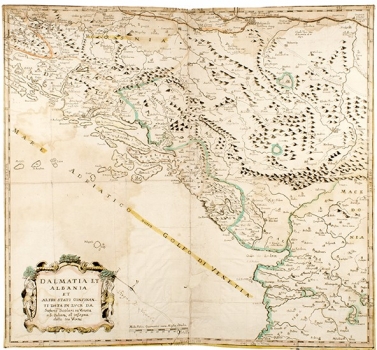
Original title: Dalmatia et Albania et altri stati confinanti
Publishing year: 1640
Place of publishing and publisher: Venezia
Format: 51 x 55 cm
Technique: Partially coloured copper engraving
Stefano Scolari was a very active publisher and copper engraver of the first half of the 17th century, but he mostly printed the maps by Gastaldi, Bertelli, Forlani and other Venetian cartographers from the 16th century. Although he sometimes changed drawings, they often seem as if they were inspired by the 16th century. This map also has all stylistic features of the 16th century, from the shapes of letters to shaded molehilles. It is very likely that this is a version of Gastaldi's map used in various works (Camocio, Bertelli, Valegio), until the end of the century. This is confirmed by the dates of Ottoman conquests, youngest of which is in 1592. Especially interesting features of the map are marked routes from Dubrovnik and Belgrade to Istanbul.
SCOLARI, STEFANO
SCOLARI, STEFANO (1598-1650 or 1657). A less known, but rather active publisher and engraver from Venice (San Zulian Street). He mostly worked in accordance with older Dutch models, which is why his maps contain features of previous centuries. In the late 16th and early 17th century, he published maps for Gastaldi, Forlani and Bertelli. He took over some templates from Marc Sadeler, and the same plates would later be published by Giacomo Franco. He often signed his maps with “all' insegna delle Tre Virtu a San Guliano”. He also worked with Zeno and Camoci, and for his maps of central Dalmatia, he used the services and expertise of the Croatian cartographer Martin Rota.