Hrvatski Deutsch English
Home Maps p-t ROSACCIO GIUSEPPE Istria
ROSACCIO, GIUSEPPE: MAP OF ISTRIA

ROSACCIO, GIUSEPPE: MAP OF ISTRIA

Inventory number 240
Original title: Istria
Publishing year: 1598
Place of publishing and publisher: Venezia
Format: 10 x 17,5 cm
Technique: Copper engraving

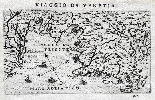
This map of Istria comes form the first edition of Rosaccio’s travel-record work «Viaggio da Venetia a Constantinopoli per Mare, e per Terra, & insieme quello di Terra Santa» of 1598. The work went through at least two another editions - 1604 and 1606. This map of Istria by Rosaccio was based on an earlier map of Istria published in 1525 by the Istrian cartographer Petar Kopić (Pietro Coppo). The map shows Istria drawn on a very small scale identifying only a few major coastal towns – Trst, Kopar, Piran, Umag, Poreč, Pula, Medulin, Labin and Rijeka. The town of Motovun is the only that is identified in the interior of Istria.  Along the right hand margin of the map parts of the islands of Krk and Cres can be seen. The relief is represented schematically as shaded molehills.

ROSACCIO, GIUSEPPE
Giuseppe Rossacio (ca 1530-1620), Italian cosmographer who worked in Venice. His most noted works are “Teatro del Cielo e Terra Florence” of 1594, the 1604 edition of Ptolemy’s “Fashion of the Four Elements” and “Teatro del Cielo” of 1615. Of the greatest importance for the depiction of the Croatian lands is his isolario “Viaggio da Venetia a Constantinopoli” comprising map images of all of the bigger islands and ports located along the navigable way leading from Venice to Constantinople, the work that from 1597 onwards went through several editions.
Print Friendly and PDF
Top